Chichén Itzá and the Maya World Beyond the Famous Pyramid
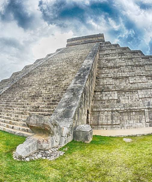
The pyramid seems familiar before you reach it. Four stairways climb a succession of terraces toward a temple, and the building rises above an open plaza with a clarity that photographs capture remarkably well. Yet standing before El Castillo reveals something a photograph cannot: the scale of the space around it.
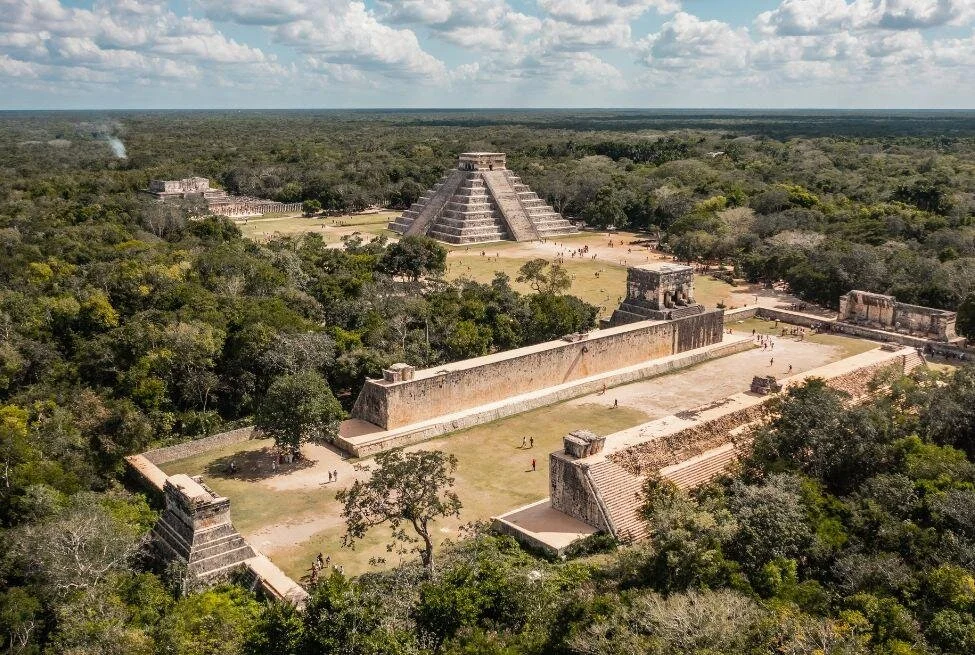
Chichén Itzá is a city, not simply a pyramid. Walk beyond its most recognisable monument and the story becomes more varied. A vast ball court gives way to carved panels. Rows of columns suggest roofed spaces that no longer survive. Farther away, a circular tower and densely decorated façades reveal other architectural approaches.
The interest lies in those differences. This was a centre of authority, worship, exchange, and public ceremony grew over time. Some questions about it have firm answers; others remain open to research. Both deserve a place in its story.
Where Chichén Itzá is located
Chichén Itzá lies in the Mexican state of Yucatán, in the northern part of the Yucatán Peninsula, near the community of Pisté. It is inland rather than on the Caribbean coast, a useful distinction for travellers planning a visit from Cancún or the Riviera Maya.
UNESCO added the Pre-Hispanic City of Chichén Itzá to the World Heritage List in 1988. Its importance rests on the scale and quality of its surviving architecture, its cultural influence, and the evidence it preserves of a major Mesoamerican civilisation. [1]
The name is commonly translated as “at the mouth of the well of the Itzá.” The reference to a well connects the city’s identity with its cenotes, the natural sinkholes that expose water in the limestone landscape. [2]
Understanding that setting matters. Water was a resource life depended on, and certain watery places also carried religious meaning. The geography belongs inside the historical explanation.
Who built Chichén Itzá?
Chichén Itzá was a Maya city. Generations of people built its surviving buildings, including rulers, craftspeople, labourers, and the communities that supported urban life.
The Maya world consisted of many centres with changing relationships. It should not be imagined as one uniform state whose cities all shared an identical history. Chichén Itzá’s architecture reflects its place in that wider world and its contacts beyond it.
The Smithsonian’s Living Maya Time project emphasises the shared cultural roots and continuing diversity of Maya peoples. That perspective helps prevent another mistake: treating the builders of an ancient city as a people who simply disappeared. Maya communities, languages, and traditions remain part of contemporary life. [3]
The ruins show an earlier society, while living people carry histories that extend beyond the archaeological record.
When the city flourished
Chichén Itzá rose to prominence during the later first millennium CE and became a dominant centre in the northern Maya lowlands. Its influence was particularly strong around the ninth and tenth centuries, although the site’s occupation and ceremonial importance cannot be confined to a single short period. [4]
A useful way to approach its chronology is to distinguish settlement, monumental construction, political power, and later pilgrimage. Those processes need not begin or end together.
A building might remain important after the government that commissioned it lost influence. A sacred place might attract visitors after substantial residential activity had declined. The decline of elite power therefore does not automatically mean that everyone left at once.
The site continued to matter as a place of pilgrimage into the colonial period and beyond. [4] Descriptions of a suddenly abandoned city, untouched until modern discovery, miss that continuity.
Chichén Itzá and the question of Toltec influence
Visitors often hear that the Toltecs invaded Chichén Itzá and transformed it. Similarities between monuments here and at Tula in central Mexico have certainly shaped that interpretation, but the relationship is more debated than a short tour explanation may suggest.
Researchers have considered migration, conquest, exchange, shared political symbolism, and interaction between different regions. The direction and timing of influence remain important questions. A scholarly discussion published through the University of Arizona Press examines how strongly invasion models have shaped earlier interpretations. [5]
The responsible conclusion is that the architectural connections matter, while one simple account should not be presented as settled fact. Similar buildings establish a question about relationships; they do not, by themselves, identify the exact journey of every person or idea involved.
For a visitor, this makes comparison more interesting. Look for repeated forms and imagery, then ask what kinds of connection might explain them.
El Castillo and the Temple of Kukulcán
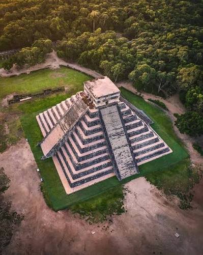
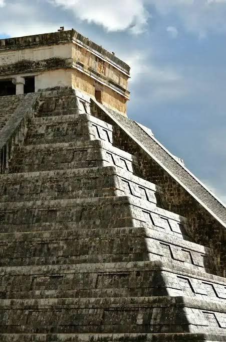
El Castillo, the Spanish name commonly used for the pyramid, is also known as the Temple of Kukulcán. Kukulcán is associated with the feathered serpent. The structure rises in nine stepped levels and reaches approximately 30 metres when its upper temple is included. [6]
The stairways organise the building with unusual visual directness. From a distance, the terraces create a strong horizontal rhythm; the stairs interrupt it with vertical lines leading toward the sanctuary above. The design makes the summit appear both central and removed from the plaza below.
A familiar calendrical interpretation counts 91 steps on each of the four stairways and adds the upper platform to arrive at 365. INAH presents this association with the solar year. [6] It is a useful introduction to the relationship between architecture and time, but it should not become a claim that every architectural feature has one universally agreed numerical meaning.
The building rewards looking from more than one permitted angle. Changing perspective reveals the relationship between its sides, the plaza, and the surrounding monuments. A single frontal photograph can hide much of that arrangement.
The serpent of light and shadow
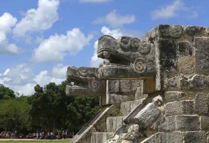
Around the spring and autumn equinoxes, afternoon sunlight creates a sequence of triangular shadows along the northern stairway balustrade. In conjunction with the serpent head at its base, the effect is popularly understood as the descending body of Kukulcán.
The spectacle has become closely associated with equinox gatherings, but it should not be reduced to a perfect clock that switches on for a few minutes on only one date. Archaeoastronomical research discusses the phenomenon over a span of dates and examines the assumptions surrounding its interpretation. [7]
Weather matters, too. Clouds can obscure the contrast needed to see the effect. No itinerary can guarantee a clear display simply by naming an equinox date.
The broader point is more substantial than the spectacle alone. Light, orientation, ceremony, and observing seasonal change can work together in the experience of a monument. Appreciating that relationship does not require pretending we know every detail of the original intention.
Maya calendars and the observation of the sky
The Maya used interlocking systems for reckoning time. Two important cycles were the 365-day Haab and the 260-day ritual calendar, commonly called the Tzolk’in in discussions of the Yucatec Maya tradition. The cycles served different purposes and operated within a broader understanding of time. [8]
Seasonal knowledge mattered to agriculture, while ceremonial calendars structured religious obligations and community life. Astronomy belonged within that setting rather than existing as a detached modern scientific discipline.
The Smithsonian documents continuing calendar-related practices among Maya communities. [8] This continuity is a useful corrective to accounts that discuss Maya knowledge only as an unsolved ancient mystery.
Avoid linking the city to predictions of the end of the world. Popular claims surrounding 2012 confused the completion of a calendrical cycle with a universal doomsday prophecy. The richness of Maya timekeeping deserves a better explanation than that. [3]
The Great Ball Court
The Great Ball Court is one of Chichén Itzá’s most imposing spaces, and INAH identifies it as the largest known example of its kind in Mesoamerica. Its long playing area, high side walls, stone rings, and associated buildings make the scale unmistakable. [9]
The game belonged to a broader Mesoamerican tradition. It combined physical activity with meanings that could extend into ceremony and political life. Carved imagery around the court includes scenes connected with ritual death and renewal.
One caution matters here: the reliefs do not prove the familiar claim that the winning captain, or alternatively the losing team, was routinely sacrificed after every match. Such a neat rule should not be supplied where the evidence does not establish it.
Spend time examining the court as a setting for spectators, authority, and performance. Its importance lies in more than the mechanics of getting a ball through a ring. The surrounding buildings helped turn an event into something publicly witnessed and remembered.
The Temple of the Warriors and the columns
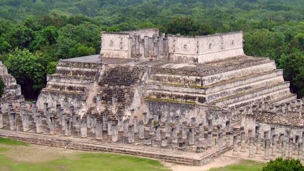
The Temple of the Warriors and the adjoining columned areas are among the strongest reminders that Chichén Itzá contained more than isolated pyramids. INAH’s site guide notes their close architectural similarities with structures at Tula, including the use of columned spaces. [10]
The surviving columns invite an act of reconstruction in the mind. Imagine the effect of roofs, shade, and enclosed movement where visitors now see open sky. The ruin is not the same visual experience as the functioning building.
“Group of the Thousand Columns” is a conventional name, not an instruction to expect exactly one thousand surviving columns. More useful than a count is the way their arrangement divides and connects space.
From the permitted visitor areas, look for the transition between the temple platform and the repeated supports. Individual details express rank and symbolism; the overall layout suggests how groups could assemble and move through the complex.
The Tzompantli and other ceremonial platforms
Among the monuments around the main plaza are the Tzompantli, the Platform of Eagles and Jaguars, and the Platform of Venus. [11] Their names highlight the imagery through which ceremonial and political ideas were expressed.
The Tzompantli is associated with skull displays. Such evidence should be presented plainly, without letting violence become the entire story of the city. Architecture, food production, family life, exchange, and craftsmanship also belong to the society that created these monuments.
The Platform of Venus points toward the importance of celestial symbolism. INAH identifies representations associated with Venus as the morning star in its decoration. [11]
These lower structures can receive less attention than El Castillo, yet they help explain the plaza as a coordinated ceremonial environment. The spaces between monuments are part of that environment, not empty gaps between attractions.
The Sacred Cenote
North of the main monumental area lies the Sacred Cenote, an open sinkhole connected to the city by an ancient causeway. It served as a place of offerings and religious significance, not simply a convenient swimming hole.
Recovered objects include materials associated with wealth, craftsmanship, and long-distance connections, along with human remains. The Peabody Museum’s account of its Chichén Itzá collection also addresses how materials moved from this sacred setting into museum storage. [12]
That history introduces questions about how archaeology has been conducted and how objects are interpreted far from their original context. A beautiful artefact can tell one story in a display case and a different, fuller story when its place of deposition is understood.
Approach the cenote as a protected archaeological and sacred feature. Swimming experiences advertised elsewhere in Yucatán are separate activities at other cenotes; they should not be confused with access to this one.
What recent research has revealed
A study published in Nature in 2024 analysed ancient DNA from 64 children buried in a subterranean chamber near the Sacred Cenote. All the individuals analysed were male, and the sample included close relatives and two pairs of identical twins. [13]
The location matters: this was a separate burial context near the cenote, not a genetic survey of everyone recovered from the Sacred Cenote itself. The findings therefore should not be generalised into a claim that every sacrifice at Chichén Itzá involved boys or twins.
The researchers discussed possible relationships with Maya narratives involving twins. Those connections are interpretations, while the biological relationships come from the genetic analysis.
The study also found evidence of genetic continuity with present-day Maya people from the region. [13] Alongside its findings about ancient ritual, it reinforces the importance of understanding this past in relation to living communities.
El Caracol and the southern buildings
El Caracol
El Caracol, often called the Observatory, stands out for its circular tower. The name refers to the spiral or snail-like form of its interior stairway. Its unusual shape sets it apart from the more familiar stepped pyramids.
INAH associates the building with astronomical observation, including Venus's movement. [14] That interpretation should be understood in the context of architecture, orientation, and Maya sky knowledge, rather than as a claim that the tower operated like a modern telescope observatory.
The building also invites us to look beyond one architectural formula. Chichén Itzá’s builders used different forms to create different relationships between interior space, elevated viewpoints, and the surrounding landscape.
Las Monjas and La Iglesia
The group known as Las Monjas includes elaborate buildings with densely worked façades. Nearby La Iglesia is an important example of Puuc architectural style, according to INAH. [15]
These are later Spanish names. “The Nunnery” and “The Church” do not establish that the buildings originally served Christian institutions. As at many archaeological sites, familiar labels reflect later observers' impressions.
The decoration rewards slower looking. Compare the patterned surfaces with the broad terraces of El Castillo. The difference is one of the clearest reasons to explore beyond the main plaza.
The Osario and the museum
The Osario provides another point of comparison within the southern part of the visitor route. The Gran Museo de Chichén Itzá includes architectural material from its upper temple, as well as displays on the city’s exchange networks and construction. [16]
A museum stop can help connect the large-scale ruins to smaller objects and architectural fragments. Check current access arrangements separately; a museum or additional sector may operate on a different schedule from the main site.
Chichén Viejo and a broader picture of the city
The area commonly called Chichén Viejo includes the Initial Series Group, an elite residential complex with living spaces and smaller temples. INAH describes managed access arrangements for this sector. [11]
Its importance is partly the change of emphasis. Monumental plazas present public authority; residential compounds offer other questions about households, status, and the organisation of daily life.
Do not assume the sector is automatically included in an ordinary walk around the main monuments. Check the latest booking, guide, group, and opening requirements before building an itinerary around it.
Archaeological sites are also working places. Access can change because of conservation, research, staffing, or special events. A closed sector does not make the rest of the city less significant.
Planning your visit
Decide how much time to give the site
Allow several hours if you want more than a photograph of El Castillo. A useful first-visit plan includes the main plaza, Great Ball Court, columned areas, Sacred Cenote, and selected southern buildings, adjusted to the weather and your walking pace.
If your tour includes lunch, a town visit, and swimming elsewhere, ask how much time is actually spent inside the archaeological site. The total excursion length can conceal a surprisingly brief archaeological visit.
A guide can help explain imagery and distinguish evidence from legend. Agree on the route, language, duration, and total charge before starting.
Choose a base that suits the journey
Pisté is close to the site, while Valladolid and Mérida can serve as regional bases. Travellers from Caribbean resort areas should factor in the inland journey and the return trip.
Compare transport plans by their complete door-to-door arrangements. Check the departure point, entrance, transfer requirements, and pickup instructions. A nearby station or a bus stop does not necessarily place you directly at the ticket gate.
For a self-arranged visit, leave enough margin for ticketing, walking, and delays. A rigid schedule can make the final hour feel like a race back to the vehicle.
Check current tickets and access rules
Use INAH’s site information and current official notices when checking admission, opening hours, concessions, and special-event arrangements. Chichén Itzá involves both federal archaeological administration and state visitor services, so a quoted charge may not always represent every component of admission. [17]
Confirm what a ticket or tour price includes. Ask whether transport, guiding, meals, and any evening programme are separate. Bring the documentation required for any concession you intend to claim.
Operational arrangements can change. INAH issues specific notices for equinox periods, when routes, access times, and availability of additional areas may differ from an ordinary day. [18]
Prepare for outdoor walking
Choose footwear suited to uneven ground and take drinking water, sun protection, and clothing appropriate for the forecast. Plan breaks rather than waiting until everyone is exhausted.
Travellers with mobility needs should ask before booking about the current accessible route, surfaces, distances, toilets, and assistance. “Accessible” is most useful when attached to a specific journey and service, not applied loosely to an entire archaeological park.
Follow barriers and staff instructions. You can view the principal monuments from authorised visitor areas; plan to appreciate the pyramid from ground level rather than expecting a climb.
Photographing Chichén Itzá thoughtfully
Start with the wide view, then look for the details that explain it. A serpent head, a carved panel, a sequence of columns, or the relationship between two buildings can communicate more than another tightly cropped pyramid photograph.
Changing light alters the contrast of the stone. You do not need an equinox visit to appreciate that. Leave room for ordinary daylight and for views without a dramatic sky.
Avoid standing on monuments, leaning across barriers, or blocking circulation for a prolonged shoot. Check current rules before bringing specialist equipment or planning commercial photography. A respectful photograph records an encounter without making the site pay for it.
Why conservation matters?
The visitor sees stone, but conservation also concerns fragile surfaces, pigments, drainage, vegetation, and the cumulative effects of use. INAH has documented conservation work across major monuments, including the ball court, pyramid, cenote, and decorated buildings. [19]
Stay on permitted paths, leave objects where they are, and avoid touching reliefs. Their survival should not depend on every visitor deciding that one small contact makes no difference.
Respect extends to people as well as structures. Ask before photographing someone closely, speak courteously with workers and vendors, and recognise that this is a place connected to present-day livelihoods and cultural identity.
The most valuable souvenir is an accurate understanding. Chichén Itzá does not need invented certainties to make it extraordinary.
A city that rewards a second look
El Castillo gives Chichén Itzá its most familiar outline. The rest of the city gives that outline meaning.
The ball court introduces public ceremony. The columns suggest spaces once covered and occupied. The cenote connects landscape with offering and belief. The southern buildings broaden the architectural story, while research continues to revise what is known about the people who lived and died here.
Give those different pieces time to come together. Chichén Itzá becomes most compelling when the famous monument stops being the end of the visit and becomes the beginning of a larger understanding.
Frequently asked questions
Where is Chichén Itzá?
Chichén Itzá is in Yucatán state, Mexico, near Pisté in the northern Yucatán Peninsula. It is inland, so visitors staying on the Caribbean coast need to allow for the journey in both directions.
Who built Chichén Itzá?
Maya communities built and developed the city over generations. Its architecture also reflects connections with other Mesoamerican regions, including central Mexico; the precise nature of those relationships remains debated. [5]
How old is Chichén Itzá?
The city developed over centuries, with a major period of political influence around the ninth and tenth centuries CE. Individual buildings and phases have different dates, so one age cannot accurately describe the whole site. [4]
What does Chichén Itzá mean?
A common translation is “at the mouth of the well of the Itzá,” referring to the Itzá people and the site’s cenotes. Translations may differ slightly in wording. [2]
What is the main pyramid called?
It is commonly called El Castillo or the Temple of Kukulcán. It is the site’s best-known monument, but it is only one part of a much larger ancient city. [6]
Can visitors climb El Castillo?
Plan to view it from the designated ground-level visitor areas. Climbing the principal pyramid is not part of an ordinary visit. Follow current signs, barriers, and INAH instructions throughout the site.
Must you visit on the exact equinox to see the serpent effect?
No. The light-and-shadow effect is associated with a span of dates around the equinoxes, and visibility depends on sunlight and weather. Visiting on one particular date does not guarantee a clear display. [7]
Can you swim in the Sacred Cenote?
No. Treat the Sacred Cenote as a protected archaeological feature, not a swimming attraction. Tours that include cenote swimming use other locations with their own access arrangements.
Were ball-game winners always sacrificed?
That frequently repeated claim is not an established universal rule. Ritual imagery at the Great Ball Court deserves careful interpretation and should not be converted into an unsupported account of what happened after every match.
How much time should you spend at Chichén Itzá?
Several hours is a practical starting point for the main monuments. Allow more time for a detailed guided visit, the museum, or additional sectors when available. Adjust the route to the heat, walking needs, and current access arrangements.
Sources and editorial notes
Research checked in October 2026. The article distinguishes archaeological evidence, conventional monument names, scholarly interpretations, and editorial travel suggestions. Recheck operational details before publication and travel. Convert the numbered references to hyperlinks as appropriate for your website.
Meta keywords are included as requested. Google does not use the meta-keywords tag for web ranking; use these phrases naturally as topics rather than repeating them throughout the text.
https://developers.google.com/search/blog/2009/09/google-does-not-use-keywords-meta-tag
[1] UNESCO World Heritage Centre — Pre-Hispanic City of Chichen-Itza. Inscription and heritage significance.
https://whc.unesco.org/en/list/483
[2] INAH — Zona Arqueológica de Chichén Itzá. Name, location, and official site information.
https://www.inah.gob.mx/zonas/146-zona-arqueologica-de-chichen-itza
[3] Smithsonian National Museum of the American Indian — Living Maya Time and The Maya People. Contemporary communities and calendar misconceptions.
https://maya.nmai.si.edu/
https://maya.nmai.si.edu/the-maya/maya-people
[4] Harvard Gazette — History of Chichén Itzá written in DNA, June 2024. Historical context and continuing pilgrimage.
https://news.harvard.edu/gazette/story/2024/06/history-of-chichen-itza-written-in-dna/
[5] University of Arizona Press — The Relationship between Tula and Chichén Itzá — Influences or Interactions. Scholarly discussion of competing explanations.
https://open.uapress.arizona.edu/read/lifeways-in-the-northern-maya-lowlands/section/576b941a-bd65-4e1a-8eb8-7c98a8e8c19b
[6] INAH — Ciudad prehispánica de Chichén-Itzá. El Castillo dimensions and calendrical interpretation. The article treats the Maya–Toltec relationship more cautiously than older summaries.
https://lugares.inah.gob.mx/es/node/6131
[7] INAH journal Arqueología — Los estudios arqueoastronómicos de El Castillo. Discussion of solar effects and their interpretation.
https://www.revistas.inah.gob.mx/index.php/arqueologia/article/download/13161/14281
[8] Smithsonian — The Calendar System. Haab and ritual-calendar cycles.
https://maya.nmai.si.edu/calendar/calendar-system
[9] INAH — Final de juego — El aro del juego de pelota de Chichén Itzá. Great Ball Court and symbolism.
https://www.inah.gob.mx/foto-del-dia/final-de-juego-el-aro-del-juego-de-pelota-de-chichen-itza
[10] INAH — Guía Chichén Itzá. Warriors complex and architectural comparisons.
https://www.difusion.inah.gob.mx/images/guias/38_chichen-itza.pdf
[11] INAH — Chichén Itzá visitor and monument catalogue. Platforms, Venus imagery, and Initial Series Group.
https://lugares.inah.gob.mx/es/node/4335
[12] Harvard Peabody Museum — From Sacred Cenote to Museum Storage. Archaeological materials and collection history.
https://peabody.harvard.edu/sacred-cenote-museum-storage
[13] Barquera and colleagues — Ancient genomes reveal insights into ritual life at Chichén Itzá. Nature 630, 912–919, 2024. Genetic findings concern a specific burial sample and are not representative of every ritual context at the site.
https://www.nature.com/articles/s41586-024-07509-7
[14] INAH — Chichén Itzá — astronomía y arquitectura. El Caracol and astronomical interpretation.
https://www.inah.gob.mx/foto-del-dia/chichen-itza-astronomia-y-arquitectura
[15] INAH — Grupo de Las Monjas and La Iglesia. Architectural context.
https://lugares.inah.gob.mx/es/pagina-de-elemento/2022
[16] INAH — Entusiasta retorno a las actividades del Gran Museo de Chichén Itzá, en Yucatán. Museum collections and interpretive themes; historical programme information is not treated as a current opening schedule.
https://www.inah.gob.mx/boletines/entusiasta-retorno-a-las-actividades-del-gran-museo-de-chichen-itza-en-yucatan
[17] INAH — Ciudad prehispánica de Chichén-Itzá. Federal and state visitor-service responsibilities.
https://lugares.inah.gob.mx/en/node/6131
[18] INAH — Operativo Equinoccio de Primavera 2026 en la Zona Arqueológica de Chichén Itzá. Example of event-specific access rules, not a year-round schedule.
https://www.inah.gob.mx/boletines/el-inah-implementara-operativo-equinoccio-de-primavera-2026-en-la-zona-arqueologica-de-chichen-itza
[19] INAH — El Promeza optimiza las zonas arqueológicas más importantes del Tramo 4 del Tren Maya — Chichén Itzá y Ek’ Balam. Conservation programme.
https://www.inah.gob.mx/boletines/el-promeza-optimiza-las-zonas-arqueologicas-mas-importantes-del-tramo-4-del-tren-maya-chichen-itza-y-ek-balam